Satellite Print of London
The Thames, the royal parks and the sprawl — from orbit.
Choose any date from 1984 to today and we'll find the real satellite capture of London from that moment — then print it on archival matte art paper, framed and ready to hang.
Create Your London Print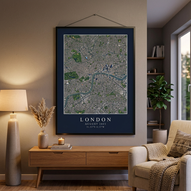
What London looks like from orbit
London reads from space as a vast low-rise sprawl with the Thames winding through it in a series of tight meanders. There is no grid to anchor on the way there is in New York, so the river does the work — the loop around the Isle of Dogs is the single most recognisable feature and the point most people locate first. The royal parks form a broken green chain across the centre.
What you can pick out in a London print
At 10 metres per pixel, these are the features that read clearly on a framed London print:
- The Thames meander wrapping the Isle of Dogs
- Hyde Park, Regent’s Park and Richmond Park as green blocks in the sprawl
- Heathrow’s parallel runways to the west
- The Lee Valley and the Olympic Park to the east
- The M25 tracing a faint ring around the entire city
The best time of year for a clear image of London
May through September generally give the cleanest captures.
London’s reputation for cloud is earned, and it genuinely affects satellite imagery — winter months frequently have no clear scene at all. If your date falls between November and February we may need to widen the search within that month to find a usable capture.
This only matters if your date is flexible. If you're printing a specific day — a wedding, a birth, the day you got the keys — we work with that date and find the clearest capture available in that month.
Frequently asked questions
How much detail can I see in a satellite print of London?
Our London prints use Sentinel-2 imagery at 10 metres per pixel, which means every pixel covers a 10 m square on the ground. You can clearly make out parks, rivers, major roads, runways, harbours and the shape of neighbourhoods. You cannot make out individual houses or cars — this is a portrait of a place, not a street-level photo.
Can I choose the exact date?
Yes. Pick any date from 1984 to the present and we search the satellite archive for a capture of London from that moment. Dates from 2015 onward use Sentinel-2 at 10 m resolution; earlier dates use the Landsat archive at 30 m, which has a softer, more painterly quality.
What if it was cloudy over London that day?
Satellites only pass overhead every few days, and cloud does sometimes obscure the exact date. When that happens we find the clearest capture within the same calendar month and tell you which date we used — we never silently substitute a different month. The best conditions over London are typically may through september.
What sizes and finishes are available?
Framed prints come in 12×16", 18×24", 24×36" from $69 to $149, printed on archival matte art paper in a black frame. A full-resolution digital download is also available for $6 on its own or alongside a framed print.
Prints of other places
London prints are popular for first homes, university years and anniversaries — but we can print anywhere on Earth, not just the cities below.
Giving a London print as a gift
Your London, on the day that mattered.
Framed prints from $69. Digital downloads from $6.
Create Your London Print