Satellite Print of Tokyo
The largest city on Earth, resolved at ten metres per pixel.
Choose any date from 1984 to today and we'll find the real satellite capture of Tokyo from that moment — then print it on archival matte art paper, framed and ready to hang.
Create Your Tokyo Print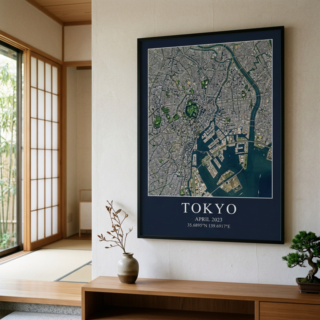
What Tokyo looks like from orbit
Tokyo is the biggest continuous built-up area on the planet, and from orbit it shows as an almost unbroken grey field spreading around the head of Tokyo Bay. What makes the print work is the contrast: the Imperial Palace grounds sit near the centre as a distinct green polygon surrounded by moats, an island of park in one of the densest urban fabrics on Earth. The bay edge is visibly engineered — decades of reclaimed land in geometric blocks.
What you can pick out in a Tokyo print
At 10 metres per pixel, these are the features that read clearly on a framed Tokyo print:
- The Imperial Palace grounds — a green, moated polygon in the dense core
- Tokyo Bay’s reclaimed islands in clean geometric blocks
- Haneda Airport’s runways built out over the water
- The Sumida and Arakawa rivers threading to the bay
- Yoyogi Park and the Meiji Shrine forest as a dark green patch near Shibuya
The best time of year for a clear image of Tokyo
October and November generally give the cleanest captures.
Autumn follows the typhoon season and brings the clearest, most stable air of the Japanese year. The June–July tsuyu rainy season is the hardest window to find a clean scene in, and late summer carries typhoon cloud.
This only matters if your date is flexible. If you're printing a specific day — a wedding, a birth, the day you got the keys — we work with that date and find the clearest capture available in that month.
Frequently asked questions
How much detail can I see in a satellite print of Tokyo?
Our Tokyo prints use Sentinel-2 imagery at 10 metres per pixel, which means every pixel covers a 10 m square on the ground. You can clearly make out parks, rivers, major roads, runways, harbours and the shape of neighbourhoods. You cannot make out individual houses or cars — this is a portrait of a place, not a street-level photo.
Can I choose the exact date?
Yes. Pick any date from 1984 to the present and we search the satellite archive for a capture of Tokyo from that moment. Dates from 2015 onward use Sentinel-2 at 10 m resolution; earlier dates use the Landsat archive at 30 m, which has a softer, more painterly quality.
What if it was cloudy over Tokyo that day?
Satellites only pass overhead every few days, and cloud does sometimes obscure the exact date. When that happens we find the clearest capture within the same calendar month and tell you which date we used — we never silently substitute a different month. The best conditions over Tokyo are typically october and november.
What sizes and finishes are available?
Framed prints come in 12×16", 18×24", 24×36" from $69 to $149, printed on archival matte art paper in a black frame. A full-resolution digital download is also available for $6 on its own or alongside a framed print.
Prints of other places
Tokyo prints are popular for travel memories, weddings abroad and expat gifts — but we can print anywhere on Earth, not just the cities below.
Giving a Tokyo print as a gift
Your Tokyo, on the day that mattered.
Framed prints from $69. Digital downloads from $6.
Create Your Tokyo Print